 David Maisel’s two aerial photography series The Lake Project (2001 – 2002) and Oblivion (2004) explore respectively the landscapes of Owens Lake and the Los Angeles metropolis. Owens Lake, a mostly dry glacial lake some two hundred miles to the northeast of Los Angeles on the Eastern side of the Sierra Nevada, was drained throughout the 20th Century to supply water to the ever-growing Los Angeles megalopolis. The desiccated Owens Lake, transformed through the immensity of water diversion projects that fed the Los Angeles Aqueduct, has become the largest toxic dust site in the United States and remains so, even with the more recent partial restoration of water flow to the site in an attempt to mitigate its toxicity.
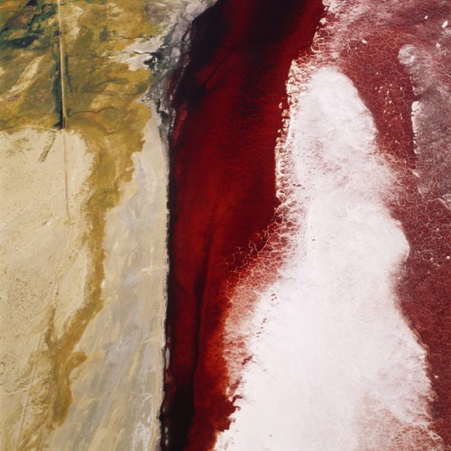
The Lake Project consists of large-scale color prints of images Maisel captured flying over Owens Lake in a small, piloted Cessna airplane. In this work Maisel exposes otherworldly views of the toxic mineral beds, rivulets, and dust clouds, the result of industrial-scale human intervention. Maisel’s mineral-based painterly color prints transform poisonous human-altered landscapes into subjects and objects of extreme beauty, while simultaneously unveiling the magnitude of hidden ecological devastation that punctuates the vast interior of the American West, a space that is often represented in the visual, cinematic, and literary arts as endless and eternal.
By contrast, Oblivion consists of tonally reversed black-and white aerial views of Los Angeles revealing ominous horizons and dark skies hovering over the megalopolis while also exposing the strange beauty and structure of the city’s arteries, axes, housing developments, and cloverleaf highways. Taken together The Lake Project and Oblivion explore the interrelatedness of the phenomenology, aesthetics, and social/political reality of the Los Angeles metropolis and the arid landscapes and fragile watersheds in which the city is embedded and on which it ultimately depends. These two series, as well as the larger body of works collectively known as Black Maps, collapse the romantic sublime of the Abstract Expressionists into the concrete and conceptual sublime of Land Art, presenting us with a distinct vision of the American West—one which is at once lethal and transcendent, compelling us to reconsider relationships of the urban to the rural and the growing consumptive addictions that drive the culture of urban sprawl.
The following interview between Lisa Tamiris Becker, Director, UNM Art Museum and David Maisel, artist and photographer, was conducted via e-mail in July and August, 2013.
LTB: Your work is overtly engaged with the long-running interest in the sublime landscape that underpins much of American Art in the 19th and 20th centuries, whether we are talking about The Hudson River School, the Abstract Expressionists, or even the Land Art movement. How do see your exploration of the “Apocalyptic Sublime” relating to these traditions?
DM: I came of age as a young artist being deeply affected by work like Walter De Maria’s Lightning Field and Robert Smithson’s Spiral Jetty. It was clear to me at the time that the spaces of the American West to which these artworks responded were unlike those I’d grown up with in the northeast. The vastness of scale and the aridness of the landscape made all the markings of human occupation and endeavor seem elemental and filled with portent. As a student of art history, I was also interested in the work of abstract expressionists that preceded so-called Land Art by several decades. I found compelling the idea of abstraction as a palpable force. In work like that of Richard Diebenkorn (an abstractionist, though not really an abstract expressionist painter) and Clyfford Still, there are clear references to landscape, and to humans as small –even insignificant– elements within that landscape. With the work in Black Maps, I’m conscious of those antecedents, and am interested in both working with them and against them in order to forge something new.
Smithson was well aware of industry’s role in changing the land, and in creating aspects (formal and political) of the sites where he chose to work. He accompanied Bernd and Hilla Becher on an artistic pilgrimage of sorts to the heavily industrialized Ruhr Valley, Germany, in 1968. (The expedition and some of the work that came out of it is documented in a remarkable book titled Field Trips). Diebenkorn was obsessed with the aerial view, having worked as a cartographer in the Marine Corps. He later was commissioned by the Bureau of Reclamation to depict water projects in the American West, and made flights from a helicopter in order to photograph the sites on which his paintings were based.
These are a number of the through lines that I have brought together in Black Maps.
LTB: What has inspired you to continue to pursue aerial photography, in spite of its inherent dangers, expense, and physical challenges?
DM: Aerial photography is a way of seeing, of mapping the land, of abstracting, and of being exposed to sites that I could not otherwise encounter. And, perhaps most importantly, it allows me to make the kinds of images that I want to make. It is simply a tool. Photography is a medium that slices into reality; it is an art of extraction. The ability to see and compose from the air is both demanding and thrilling. It is rather like an out of body experience, when the aircraft is angling obliquely into a steep bank, and you feel the g-forces growing, and the planes of the earth are torqueing and twisting in extraordinary ways that could otherwise never happen.
Photographing from the air interests me not as a method, per se, but as a way to see the otherwise unseeable and unimaginable, and as a way in which time and space can get strung together. From a moving plane, naturally, I am never in the same place twice, so no image can be repeated—it is a stream of images and possible framings that is not unlike the stream of consciousness itself. Motion gets dissected and reanimated.
Working from the air allows me to see things that are secret. The deconstructed landscapes of strip mines, cyanide leaching fields, tailings ponds, and drained lake beds seem to me to be the contemplative gardens of our time; they are like subterranean dream worlds demanding to be brought into the light of day. I think of my pictures not as simply documents of these blighted sites, but as poetic renderings that might somehow reflect back the human psyche that made them.
Ultimately, I don’t consider my aerial work to be documentary images—they are not pure in that respect. They are theoretical, not cartographic; they are as interested in exploring the unconscious as the objective. They have my thumbprint all over them. They are, in a sense, meditations. Frederick Sommer made horizonless views of the Arizona desert in the 1940’s. He said of this work that they became internal landscapes as much as external ones, and I think the same is true with my Black Maps aerial work.
LTB: How do you see your work in relationship to 19th-century exploratory photographers such as Timothy O’Sullivan and William Henry Jackson? And in relationship to more recent photographic movements such as New Topographics.
DM: Those photographers were surveyors, they were explorers, consummate technicians and craftsmen. The legacy of their images has informed our sense of the American West to this day. In some ways photographers like Carleton Watkins were responsible for articulating, or re-presenting, the myth of the American West as an undisturbed Eden. In fact, Watkins’ work in Yosemite from the 1860’s seems to intentionally adopt the tropes of the picturesque and the sublime—modes of landscape depiction that the Hudson River School had previously established. (Joel Snyder writes about this in WJT Mitchell’s Landscape and Power). Where they existed, signs of human presence (mining sites, railroad cuts, etc.) were frequently portrayed either uncritically, or even celebrated for their harmony with the land.
Conversely, the photographers identified with the New Topographics School sought to strip away any romanticized notion of the American West, and to present it in the mode that you’ve called “the anti-sublime.” From this group, I feel that the most compelling images were made by Lewis Baltz. There is a cumulative power–and perhaps, horror–in his stripped-back images of facades and construction sites, wasted peripheries and entropic zones.
Both of these aspects of the cumulative history of photography of the American West inform my work. On the one hand, as in the work of the New Topographics, I’m interested in exploring zones of intrusion, where human endeavor has impacted the land. On the other hand, I also see myself as an explorer similar to those of the 19th century exploratory photographers, in that I am creating images of sites heretofore unseen, or unconsidered.
LTB: What influenced your decision to work in black-and-white for the Oblivion series, while using color forThe Lake Project as well as most of the other BLACK MAPS series?
DM: In my early years as a photographer, I worked only in black-and-white. Indeed, Black Maps and The Forest, my first two extensive aerial projects, were made in black-and-white. But eventually I realized that the incredibly toxic, vibrant, awful, and seductive colors of the mining sites were critical to their power. In 1989, I began to work in color, and that shift really accelerated and intensified the aspects of my work that twinned together these two poles of repulsion and beauty. While it is the dominant method with which I approach landscape-based work, I felt that with Oblivion, I wanted to see the city of Los Angeles and its environs in ways that were wholly unfamiliar. So, in addition to being photographed in black-and-white, the images in Oblivion have been tonally inverted, creating a kind of x-ray of the city.
LTB: How do you see the mineral-based pigment prints of your work relating to the subjects of mineral beds and mineral toxicity that you explore in The Lake Project and other BLACK MAPS series such as Terminal Mirage?
DM: While much of the work in Black Maps shows sites that have undergone extreme environmental transformations, the bodies of work together describe the basic components of photography. From clear-cut logging sites in The Forest, paper is created; the various mining projects permit the mineral and metallic elements of photography to be harvested; and The Lake Project describes a massive water reclamation scheme, and water is essential to processing of photographs.
In recent years as I began to work with pigment prints, I realized that once again my photography was reliant on the very elements pictured in the images I was making. And this echoes the notion that we are all complicit in these sites, and in these images.
LTB: Desertification and desiccation are topics of increasing relevance to many regions of the world, including the American Southwest and Southern/Central California, in particular. Do you see your work as creating greater awareness of our depletion of water resources and our preparedness for contending with increasingly arid environments? Do you see your work as cultivating an ecological consciousness?
DM: I’ve been reading Wallace Stegner recently. I’ve come to his work rather late, but last week I went to the public library and gathered everything I could lay my hands on. How could I have spent three decades thinking about the spaces of the American West and the environmental problems they face without delving deeply into Stegner until now? In a 1987 publication titled The American West as Living Space, Stegner writes that
…the West is defined…by inadequate rainfall, which means a general deficiency of water…And what do you do about aridity, if you are a nation inured to plenty and impatient of restrictions and led westward by pillars of fire and cloud? You may deny it for a while. Then you must either adapt to it or try to engineer it out of existence.
Just to be clear, Stegner did not believe either of those two solutions was tenable.
I do feel that my work is implicitly political, though the elements of advocacy in my work are not dominant. Certainly my focus on such contested landscapes for the past thirty years is indicative of my concerns.
Owens Lake, site of The Lake Project, holds a pivotal position in the history and rampant development of southern California. A desiccated 150-square mile lakebed on the eastern side of the Sierra Mountains, it had been a body of water for 78 million years prior to its destruction. Beginning in 1913, the Owens River was diverted into the Los Angeles Aqueduct to supply water to the fledgling desert city of Los Angeles, some 233 miles to the south. By 1926, the lake was depleted, leaving a vast playa of exposed mineral deposits and salt flats. Once lush farmland, the Owens Valley became an environmental disaster, a wasteland. Water from the Owens Valley came to supply sixty percent of the water for Los Angeles, enabling the rapid expansion of this megalopolis.
No act of radical intervention on this scale occurs without unintended consequences. As Owens Lake was consumed, winds sweeping through Owens Valley would dislodge microscopic particles from the lakebed, creating carcinogenic dust storms. By 2001 it had become the highest source of particulate matter pollution in North America, emitting 300,000 metric tons of dust annually. Dust from Owens Lake contains toxic heavy metals such as arsenic, nickel, selenium, and cadmium. Naturally occurring in the lake, these metals became exposed as the lake was drained. The poisonous dust particles are so small that they infiltrate lung tissue when inhaled and remain permanently in the human body.
Natural resource extraction and its consequences are themes central to my photographic practice that I’ve pursued passionately for three decades. Through aerial photography, the series Black Maps, The Mining Project, and American Mine explore sites across the United States that have been radically and irretrievably transformed by open pit mining. These images encompass documentary and aesthetic perspectives in equal measure, seeking to frame and interpret issues of contemporary landscape and culture. Literally and figuratively, the Earth’s consumption is revealed.
The Mining Project considers sites like the Berkeley Mine in Butte, Montana, whose open pit is filled with severely poisoned water a mile deep and nine hundred feet wide. American Mine features open pit mines on the Carlin Trend, the most prolific gold mining district in the Western Hemisphere. Mines from this region are the source of devastating mercury emissions, released when ore is heated during the process of gold extraction. Both series depict the calamitous practice of cyanide and sulfuric acid heap leaching, employed to extract microscopic particles of precious metals from mined ore, which often permit these deadly solutions to contaminate surrounding groundwater.
Inconceivably, federal legislation governing mining activity in the United States dates from more than 135 years ago. The legacy of the 1872 Mining Law, ratified in an era when America sought to develop the West and exploit natural resources without regard to environmental impact, has left this land deeply scarred. Current mining techniques carve out entire mountains and utilize tons of toxic chemicals at massive industrial sites. According to the Environmental Protection Agency, mining has become America’s largest source of toxic pollution. Further, the mining industry is a globalized one, whose practices are often less regulated in other countries.
Metals extracted from the Earth by open pit mining are used to manufacture products that we global citizens employ on a daily basis. The mines and their surrounding expanse of tailings ponds and cyanide leaching fields are byproducts of the developed nations’ culture of consumption. Our infrastructure, our technology, our transportation systems, and even the medium of photography itself, are all reliant on metals extracted from the Earth’s crust in methods both brutal and complex.
Of course, none of this is explicitly stated in my photographs, which are formal and abstract as well as being highly descriptive. I don’t caption my images or even title them in a manner meant to sway audience reaction. I want them to exist as visual images first and foremost, but their power comes from examining sites that are contested, difficult, and damaged. They are intended to offer a sense of what has been lost, what the structure and forms of our civilization are taking, and perhaps, views of the problems we face and that we’ve collectively created.
LTB: In many of your works the collapse of scale is critical to the sense of otherworldliness that results. In several works for example, what appears to be an amalgam of blood vessels perhaps, is actually a large terrain of toxic mineral beds viewed from an airplane, for example. How consciously do you manipulate scale in your work and to what end?
DM: I don’t know that I am manipulating scale, so much as I am responding to it. From the air, the site of Owens Lake certainly takes on aspects of the human body. I began to treat my work in The Lake Project as an autopsy of Owens Lake. An apt phrase; to autopsy means to see for oneself. At Owens Lake, the blood red waters seem like veins and arteries, and certain images can feel strangely like we are within the brain or the heart. In fact, after he saw the images in The Lake Project, a cardiac surgeon invite me into his OR so that I could witness just how similar open heart surgery looks to some of the images I’d made at Owens Lake.
LTB: Given that you have been photographing the American West for over two decades now, what changes have you observed in that time period? Are you compelled for example, to return to Owens Lake and see how that place looks today?
DM: Owens Lake is a site that I would like to return to every decade or so. I like the idea of charting changes to this particular site over time. In fact, in the two years I spent working there on The Lake Project, the changes to the dry lakebed were massive in scale. The EPA had mandated specific modifications to the dry lakebed in an attempt to quell the toxic dust storms arising from the playa. Between 2001 and 2002, a vast area of the lakebed, many hundreds of acres in size, was covered with drip irrigation tubing; some 15% of the water drained from the lake and intended for Los Angeles was instead diverted back onto the lakebed to dampen the surface enough to keep dust storms from forming. It is at this point a kind of synthetic landscape, with many successive layers of human intervention.
LTB: I believe you grew up and came of age in Long Island, New York, a place that has been radically transformed through human intervention, land development, industry, etc. over the last two centuries and a place where connections with the natural world are nonetheless still evident, particularly because of the omnipresence of the Long Island Sound and the Atlantic Ocean. How would you say that your experiences there might have influenced your work and perhaps your passion for environmental concerns?
DM: Well, Long Island was a synthetic landscape, too. I lived in the same house on the same street for the first eighteen years of my life, and returned to visit my parents there until I was in my late 30’s. The street had a kind of Levittown aspect to it; each home on my side of the street had originated with exactly the same floor plan. Ranch house, ranch house, ranch house. As a small kid, I was acutely aware of how each house had, over time, shifted in subtle ways as the occupants made changes. Variation within sameness. I recall how otherworldly it felt when I discovered, perhaps as an 8-year old, that the homes around the block from mine, whose backyards bordered my own, were again the same home endlessly repeated, but with their floor plansinverted. That was the strangest science fiction I could have imagined, and it fueled my sense of how the uncanny coexists alongside the prosaic.
I lived in that house when I saw footage of men walking on the moon, and lived there when I saw TV coverage of Lake Erie on fire. Within a year or two I formed the ecology club in my middle school. The club sold seedlings of pine trees; eventually a few of them that I had planted outside my parents’ bedroom grew taller than our house. I suppose all of those events were formative on some level.
LTB: You cite your studies at Princeton with Emmet Gowin and Edward Ranney as seminal in your development and engagement with contemporary exploratory photography. How did these mentors influence your work?
DM: To describe Emmet Gowin and Edward Ranney as photographic educators only begins to skim the surface of their impact on me as a young artist; they were philosophers and exemplars, as well. They showed me, through their quietly profound work and their dedicated working methods, that if photography provides anything at all, it is as a platform for inquiry, or, as Emmet has described it, “the natural exhilaration of an encounter with the unknown.”
As an undergraduate student, I had the opportunity to accompany Emmet Gowin on a photographic expedition to the aftermath of the volcano Mount St. Helens. This was a profoundly formative experience for me. I witnessed the landscape being taken apart on a seemingly biblical scale by not only the natural disaster of the volcano, but also by the actions of the logging industry that were clear–cutting in the area. I also worked from an airplane for the first time, and I was immediately captivated by the abstracted and distanced view of the earth afforded by the aerial perspective.
At the time I studied with him, Ed Ranney was engaged in his photographic survey of Mayan and Incan architecture. I think that from Ed I absorbed the idea of thinking of myself as an archaeologist, examining the artifacts left by civilizations in the lands they had occupied. However, with my work, I was representing a kind of future past- that is, I was documenting and cataloguing that which our current civilization might leave behind once we have vanished.
The CU Art Museum touring exhibition David Maisel/Black Maps: American Landscape and the Apocalyptic Sublime is curated by Lisa Tamiris Becker, Director, UNM Art Museum and Helmut Müller-Sievers, Director, Center for Humanities and the Arts, Eaton Professor of Humanities, University of Colorado Boulder. The introduction for this interview is an excerpt from Ms. Becker’s curatorial statement from the exhibit.
The exhibition, which premiered at the CU Art Museum in 2013 was recently on view at the Scottsdale Museum of Contemporary Art and will travel to the University of New Mexico Art Museum for exhibition in the Fall of 2014. The UNM Art Museum is also planning a major symposium to explore the multiplicity of meanings emanating from David Maisel’s Black Maps work and the symposium will focus on subjects such as aesthetics and history of aerial photography in the American West; aesthetics, sustainability, and land-use in the American West; the relationship of Maisel’s work to Land Art and practices of Art and Ecology; as well as the relationship of Maisel’s work to the historic and contemporary sublime. For more information about the symposium please e-mail Lisa Tamiris Becker at lbecker@unm.edu.
Lisa Tamiris Becker led the CU Art Museum in Boulder, CO for ten years and in 2013 was appointed director of the University of New Mexico Art Museum. She has curated and organized over fifty major exhibitions of contemporary art.
David Maisel is a San Francisco-based photographer whose large-scale photographs explore the visible traces of mining, logging, water reclamation, and military testing. His work has been collected and exhibited internationally, including at the Metropolitan Museum of Art, the Los Angeles County Museum of Art, the Victoria & Albert Museum, the Brooklyn Museum of Art, the Santa Barbara Museum of Art, the Yale University Art Gallery; and the Museum of Fine Arts, Houston.